

Groundwater Monitoring
City of Newcastle established a groundwater monitoring program at Summerhill Waste Management Centre in 1993 to characterise background water quality prior to landfilling and to allow identification of potential impacts on groundwater quality and groundwater levels once landfilling commenced. Groundwater impacts from landfilling would most likely arise from the migration of leachate from within the landfill.
A system of groundwater monitoring bores has been installed in stages as the site has developed. The monitoring program involves collecting groundwater samples from these groundwater wells (when the water is present) four times per annum. Samples are tested for a restricted list of analytes on three occasions and for a more comprehensive list of analytes annually, in accordance with Environment Protection Licence requirements.
The groundwater bore network surrounds the following high risk areas:
- General Solid Waste (Putrescible) (GSWP) landfill
- General Solid Waste (Non-Putrescible) (GSWNP) landfill
- Former building and demolition waste (FBDW) site
- Landfill leachate holding ponds.
The groundwater bore network is indicated on the Environmental Monitoring Location Map (reference Environmental Protection Licence 5897, location of monitoring points and areas).
A number of geotechnical and hydro-geological studies were conducted prior to SWMC being approved. These studies identified the previously mined coal measures underlying the site as the most hydraulically permeable strata in the formations present – although un-fractured coal's hydraulic conductivity is relatively low. Coal seams beneath the site dip generally to the southeast or southwest.
Thus, in locations downgradient from the landfill, it was attempted to install the groundwater monitoring bore screens in coal seams. Upgradient bores (north of the landfill) are located in areas where the coal outcrop has been mined by open cut methods, so seams are not present. Those bores are screened at depths between 5 and 35 mAHD.
Those initial hydro-geological studies and early groundwater sampling also suggested that groundwater levels beneath the site had been artificially lowered by past mining and mine de-watering activities at the adjacent Gretley Colliery. This meant many potentially downgradient bores were dry.
Those same reports anticipated that groundwater levels may rise when de-watering activities stopped at Gretley, although it was noted that groundwater levels could only rise to the elevation of any discharge points from old workings. Since de-watering ceased at Gretley in 2008, groundwater levels beneath SWMC have not trended upwards, supporting the previous assertion.
A schematic cross-section detailing the geology beneath SWMC and what was considered as the potential rise in groundwater levels - see below. That cross-section was extracted from one of the abovementioned independent reports (CMPS&F, 1997).
Section through Summerhill waste management site and surrounding area

Since commencing groundwater sampling, Council has engaged independent consultants to review the monitoring data and monitoring program on a number of occasions, and has provided those reviews to the NSW EPA. Those reviews have supported the hydro-geological model described above, and have suggested that in many cases, water extracted from bores during sampling represents surface water or condensation pooled within the bores. This is supported by records of static water levels and the variable chemistry of water between bores.
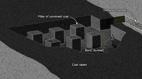
The results of the data reviews are not surprising in view of the previous underground bord and pillar coal mining that took place beneath the site. In bord and pillar mining a regular grid of intersecting tunnels are driven into the coal seams. These tunnels are the bords, and the remnant blocks of coal left between the bords are the pillars. These pillars support the overlying strata during the extraction of the bords, a process known as the first workings. The pillars may be subsequently partially extracted during the second workings, depending on the site. By the end of mining, at least some of the pillars will remain between the voids left from the extraction process. An idealised schematic diagram of bord and pillar extraction from the Encyclopaedia of New Zealand is shown below.
Bord and pillar extraction schematic diagram (Source: Encyclopaedia of New Zealand)
Due to these previous coal extraction techniques, when groundwater monitoring bores are installed at the SWMC site, it is a matter of chance whether the bores intersect remnant pillars of coal or voids left after mining. Bores intersecting pillars are unlikely to encounter groundwater, as that groundwater would follow preferential flow paths in the voids between pillars (intact coal is relatively impermeable). As mine discharge points exist at lower (down-dip) elevations than that of the coal seams beneath the SWMC site, the voids cannot become flooded, and so monitoring bores which intersect voids are also unlikely to encounter groundwater.
Despite the low probability of obtaining meaningful data, SWMC’s Environment Protection Licence still requires groundwater monitoring. Recent results of that monitoring are available on this web site. An analysis of data trends etc is provided in SWMC’s Annual Environmental Report.
